Click on an item on the map to view information about it

Angle Peak Loop
Chelan,
Washington
overview
LENGTH : 11 miles, loop
ELEVATION GAIN : 2,600 ft.
TYPE : hike
HIGH POINT : 6,890 ft.
Angle Peak is a small prominence along Devil's Backbone, which divides Chelan and Entiat valleys. The peak in and of itself is not particularly noteworthy, however it's a junction of Angle Peak and Devil's Backbone (as well as Four Mile Ridge trail), providing the opportunity for a fun loop through sun exposed ridges and forested mountain streams. The 15 mile drive along dirt forest service road to the Crescent Hill Trailhead means it's more popular with dirt bikers than hikers; however, it's worth the trek if you are looking for a more challenging hike around the Chelan Valley.
The loop can be hiked in either direction. Hiking clockwise will take you along Devil's Backbone, which has moderate up and down, before turning onto Angle Peak trail, which steadily descends into a forested valley, crossing and following a number of creeks along the way. Upon reaching the Lake Creek trail, you began a steady climb back up to Devil's Backbone to finish out the hike. Hiking counter clockwise has you descending down Lake Creek trail after a short ascent up from the parking lot, and then doing a steady climb up the forested Angle Peak trail, before turning left onto Devil's Backbone for a little over 3 mile hike back to the trailhead.
Placeholder in dev for ad
Directions
Parking
Trip Reports
August 25, 2024
DOWNLOAD GPXTOTAL MILEAGE : 11.1 miles, loop
ELEVATION GAIN : 2,680 ft.
HIGH POINT : 6,890 ft.
I attempted this hike in June when my brother was visiting, but snow altered our plans and we only hiked a couple of miles along Devil's Backbone. Certain I wasn't going to encounter snow in August, I made the trek up to Crescent Hill Trailhead on a Sunday and was surprised to see fresh snow blanketing a couple of the higher peaks up North! Fortunately, the unusually cold and rainy Saturday had only resulted in a little bit of frost, and seemed to spruce up the flora, as the hike was more green than expected.
There was one other car at the trailhead, a gentleman who appeared to bew checking out the area as he left shortly after I arrived. Enjoying the solitude of an empty trailhead, I began the short ascent up to the ridge. I started the hike with a fleece on, and didn't take the fleece off until I began my final ascent at the end of the hike, which is not something I would have expected in August. While the start of the hike had clear skies, the clouds eventually rolled in, and I don't know if the temperature ever touched the 60s during my hike.
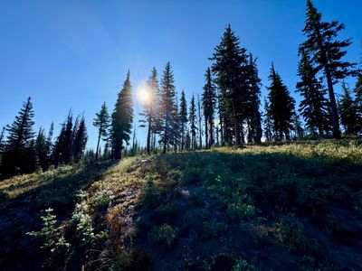
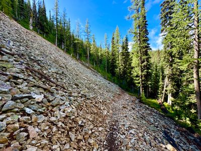
Start of the hike
Hiking along Devil's Backbone, I was amazed at the wildflowers. The recent rains must have revitalized everything at higher elevations, as I saw Lupine, Penstemon and Indian Paintbrush all in bloom. It wasn't like the spring, where there are wildflowers everywhere you look, but there was still a decent amount given the time of year.
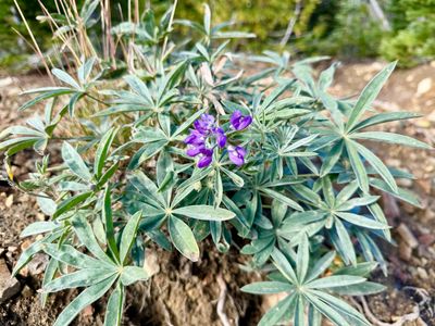
Lupine in bloom
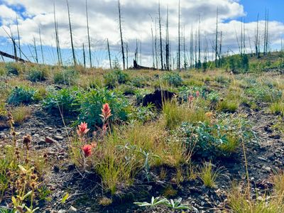
Indian Paintbrush
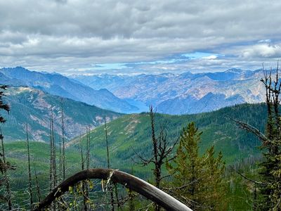
The hike along Devil's Backbone is nice, with views into the various valleys that connect into Twenty Five Mile Creek, however there are no views of Lake Chelan during this section, as it's hidden behind Grouse Mountain, Slide Ridge and other peaks. I passed by East Peak, which is a small prominence where my brother and I turned around in June and eventually reached the junction with Angle Peak, which was about 3.1 miles from the start. I opted to continue on a short bit as the map showed Angle Peak summit next to the junction with Four Mile Ridge. There really isn't any sort of discernible summit, however just past the junction with Four Mile Ridge there was a nice clearing with views down into the Entiat Valley.
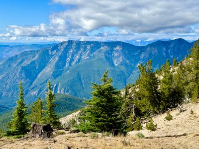
Entiat Valley
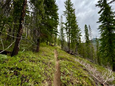
I retraced my steps and started hiking along the Angle Peak trail. It fairly quickly starts to descend down into the Entiat Valley, with a number of switchbacks and I passed through a pretty scree field. Shortly thereafter, two dirt bikers were coming up the trail, they had passed by me on Devil's Backbone, and they had to turn around due to a large log across the trail. I saw one other dirt biker later in the hike along Lake Creek Trail, but otherwise it was a quiet day in the mountains.
Angle Peak trail
I crossed a small creek a couple of times, and the flora noticeably changed, with mushrooms, ferns and other green plants blanketing the forest floor. It felt a bit like being on the west side of the Cascades, and was noticeably different from what I had just been hiking on Devil's Backbone. There were some peekaboo views of the Entiat Valley, and at one point I ventured off the trail to see if I could get a better view. Although there weren't sweeping views, I found some larches scattered around another scree field.
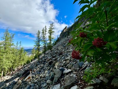
Another scree field
This section of the trail probably would have been better to ascend rather than descend, especially if the temperatures were more normal for August. It was well shaded in the thick forest, with no signs of any recent fires scarring the trees, while the ascent up from Lake Creek was more open, with trees thinned out from an old forest fire.
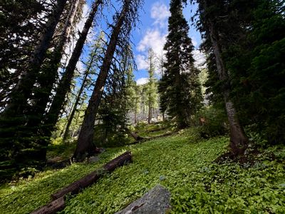
Greenery on the Angle Peak trail
As I progressed down the trail, the stream continued to grow in size, with other streams feeding in along the way. A couple of sections where the trail crossed the stream required a little bit of work to stay dry, and on one crossing I slipped on a rock and got my feet soaked.
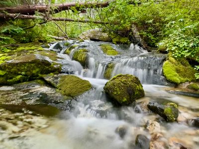
Creek along the trail
Towards the end of the Angle Peak trail, there was a section where there were a huge number of downed trees. It looked like a fire may have killed the trees a number of years ago, and now they were falling over, but it was hard to tell. Perhaps it was an insect infestation like the Spruce Budworm?
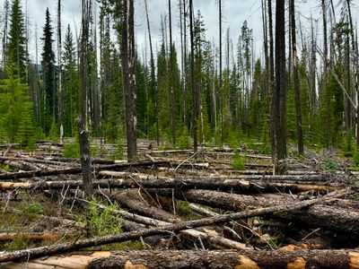
Downed Trees
Reaching the junction with the Lake Creek trail, I took a short break to hydrate and eat, and then began the ascent up to Devil's Backbone. The trail, while not as interesting as Angle Peak, had a nice pitch to it and I steadily climbed up the mountainside.
Lake Creek trail
Fortunately, the temperatures were still fairly cool with a thick cloud layer above me now, and while I had to shed my fleece, it wasn't too hot on the hike up. Near the junction with the Devil's Backbone trail I caught my first views of Lake Chelan while on the hike, with a nice view uplake of the North Cascades. I was surprised I couldn't see any fire damage from the Pioneer Fire, as in June we saw a plume of smoke not too far uplake the day the fire started.
Lake Chelan
It was nice to complete this hike, it's been one I have been meaning to do. Four Mile Ridge looks like an interesting trail, and I may have to come back to this area in the fall to see if I can find some more stands of Larch.