
Castle Rock
Wenatchee,
Washington
Overview
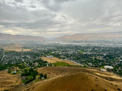
Castle Rock is a prominent basalt butte standing over Wenatchee, and provides a quick and convenient hike within the city limits, with unobstructed views of Wenatchee, the Columbia River and surrounding foothills. It's a popular hike in the spring when wildflowers carpet the slopes, and is also open during the winter months, unlike other trails in the area (although it's recommended to stay off the trails when muddy to help preserve the trailbed. Refer to CDLT for more information.).
The lower section of Castle Rock has a number of interconnecting trails, which provide a variety of ways to make your way up to the top. The intersections have a map showing the current location within the trail system, so it is typically pretty straightforward to navigate. However it's helpful to have a route in mind prior to hiking and also have a copy of the trails for reference. Which ever route you take will converge into a single trail which continues up the mountain and enters land managed by Chelan Douglas Land Trust. The trail then splits into a loop around Castle Rock, connecting back up on the ridge, where you can take the spur trail up to the top of Castle Rock. If you wish to extend the hike after summiting Castle Rock, proceed down to the ridge and continue up the 1:2 Divide trail. Otherwise, head back down towards the trailhead, potentially taking a different trail than on the way up.
Directions
Parking
Trip Reports
Finding myself with a couple of hours to kill in Wenatchee while my wife and son were watching a movie, I decided to hike up Castle Rock. With weather feeling more like fall with the cooler temps and rain showers, I consulted the forecast and radar and it looked like there would be minimal precipitation, if any, while I was doing the hike. Boy was I wrong...
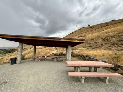
There were two cars at the trailhead when I arrived, leaving one spot open for me. It's surprising they have such limited parking, as it is a nice trailhead with a picnic shelter and vault toilet, and it looks like they could have squeezed in additional spots. Counting my blessings for finding parking, and no rain, I headed up to the start of the trails. Although this was my first time at Castle Rock, I knew there were a number of interconnected trails at the start, and I would take the leftmost trail as that looked to be the most direct route to the top. I didn't realize you basically have to walk through the picnic shelter to get to the trail, which fortunately was empty.
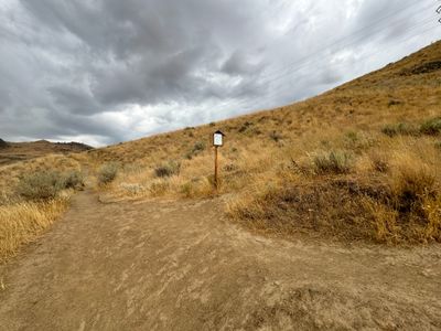
I quickly came to my first trail junction, which had a convenient map with the current location highlighted. I knew I would be heading left at the various junctions, and had the Castle Rock trail system from my website ready on my phone, but it was still nice to be able to do a quick visual check to ensure I was heading up the route I had planned. There were a number of unofficial trails breaking off along the way, and they have done a good job posting signs indicating you should not take those trails due to vegetation rehabilitation.
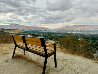
I saw a woman come running down one of the other trails to my right, and that was the only person I saw for the rest of the hike. No sooner had she bombed past, then a light rain began. I passed by a bench situated on a flat spot, and it would have been a nice place to take in the views, but I was short on time and sitting in the rain, even though it was just a light drizzle, didn't sound appealing.
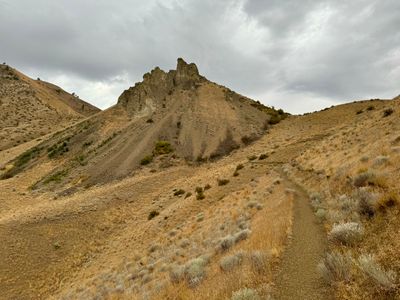
All the trails converged into a single trail heading up towards Castle Rock, impressively looming off in the distance. From this vantage point, it was hard to figure out how the trail would progress up Castle Rock, as it looked fairly steep. I passed by a sign indicating no bicycles were allowed and this area is managed by Chelan Douglas Land Trust (CDLT). It's impressive what CDLT has done in the area, conserving land while also maintaining access to hiking and biking trails, with Castle Rock being a prime example.
The rain had now intensified, and I was forced to put on my rain jacket. I attempted to leave the front open, as it was still relatively warm out, but I was getting drenched. So I opened my pit vents and slowed my pace, hoping the heavier rain would quickly pass through. I came to the split in the trail and headed left, as it looked like a cool hike underneath Castle Rock, and as I was making my way up to the ridge, I saw a flash of lightning followed by thunder. The time difference was around 5 seconds, so it was still a ways off, but definitely concerning.
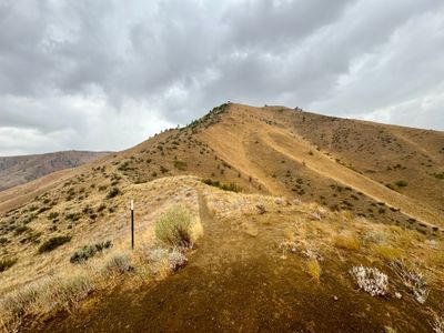
Reaching the ridge where the Castle Rock trail continued up to the top and the 1:2 Divide continued up the ridge, I stopped to consider if I should progress any further., given I would be a lot more exposed on the final trail up to the top. There hadn't been any additional lightning, and I decided to go for it, knowing I would turn around if there was more lightning, especially if it was close. I reached the top without incident, quickly snapped a photo, and started making my way down. I was about half way down when another bolt of lightning struck, however given the delay in the thunder, it was still over 5 miles away.
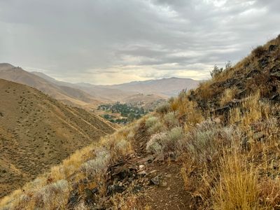
Reaching the ridge, I opted to head around to the right to check out this section of the trail. It was still raining hard, with no end in sight, and I had to be careful of not going too fast, as this section of the trail traversed along a steep slope and with the rain, was a bit slippery. Last thing I needed was to slip and slide down the side of the mountain...
Once down off of the side of Castle Rock, I started to run down the trail. It was pouring rain, but fortunately the trail wasn't muddy yet, with its hard compact surface shedding the rain. Towards the bottom, sections of the trail had streams running down them and my shoes were completely soaked. I stopped under the picnic shelter to fish out my keys and then ran to the car, completely soaked!
Although the rain caught me by surprise, it was a fun hike. The view is great, and even though it's short, it's good exercise with the elevation gain. Would be great to hike in the spring, when the balsamroot starts flowering.