
Mills Canyon
Entiat,
Washington
Overview
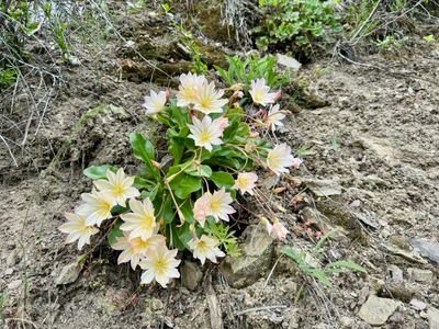
While Mills Canyon is often the starting or ending point for a hike up to Keystone Point, for those looking for a less arduous hike, the forest service roads which wind through Mills Canyon checks the box. Mills Canyon was once a thick forest, however the Dickleman Fire of 1988 and the Mills Canyon fire of 2014 decimated the pine trees. Now Mills Canyon is home to an astonishing array of flowers, including the beautiful Tweedy’s Lewisia, which typically blooms in May. This hike follows the Entiat Ridge Forest Service Road (which is an extension of the Mills Canyon Road) as it climbs up out of Mills Canyon. While you may encounter someone driving on the road, it is a fairly rough road and doesn't see a lot of traffic. Hike up the road until you have had your fill of wildflowers, and then retrace your steps back to the car.
Directions
Parking
Trip Reports
Having spotted a single Tweedy's Lewisia on a hike around Lone Peak in the Lake Chelan area a couple of years ago, I had been meaning to find some more. I had heard that Mills Canyon had quite a few of them and while the hike to Keystone Point looked interesting, it was going to be too long for a family hike. So I decided we would drive part way up Mills Canyon and then walk the forest service road in search of Tweedy's Lewisia.
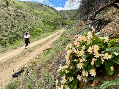
I pulled into a grassy area before the road started ascending with the intention of parking here, but after checking the map, I decided we would drive a little higher. There didn't seem to be much in bloom at this elevation, and I wasn't sure how long of a hike I was going to be able to get my son to do. The road was rough in spots as we ascended, but not too bad and fairly soon there were lots of wildflowers in bloom and I found a pull out to park the car. Right next to the car the Arrowleaf Balsamroot and Lupine were in bloom.
We began the hike up the forest service road. I tried unsuccessfully to explain what Tweedy's Lewisia looked like to my wife and son, as we scanned the hillside for the flower. After hiking for maybe 10 minutes, we spotted our first one. And then another, and another… This section of the road didn't have huge clusters of them, but they were a good amount.
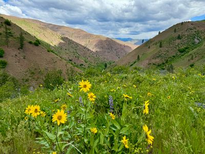
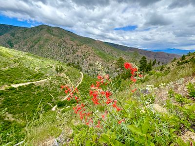
Soon the novelty of spotting Tweedy's Lewisia wore off, but there were many different kinds of wildflowers and the area is quite beautiful. I had recently hiked at Echo Ridge in Lake Chelan, and there were very few wildflowers in bloom, while this area seemed more lush and there were wildflowers everywhere you looked.
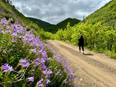
My wife and son were making fun of me, as I couldn't stop taking photos of all the wildflowers, especially the Tweedy's Lewisia. But with clusters of Wood's Rose, Lupine, Penstemon and more, it was hard to resist taking photos.
The road had a nice steady incline, and soon we were high up over the valley. Even though this area has been ravaged by fires over the years and lacks large trees, it is still very scenic and there are a lot of shrubs and small trees in addition to the wildflowers.
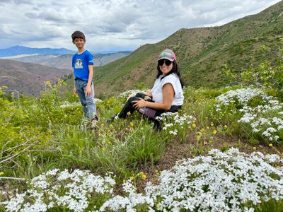
About a mile and a half in, we found a nice spot off the road amongst a patch of wildflowers to take a break, hydrate and enjoy the views. It actually started lightly raining on us, and off in the distance over Devil's Backbone it looked like there was considerable rain. But the rain soon let up as we made our way back down the road.
On the way down a hiker passed by us. She mentioned she had been on her way to Keystone Point when she scared a small bear up a tree. Worried that the mother may be nearby, she headed back down. We didn't have any wildlife encounters, but we did have a car and two quads pass us on the road. It was a fun hike, with loads of wildflowers. I'll come back on my own next spring to make the hike up to Keystone Point.