
Slide Ridge
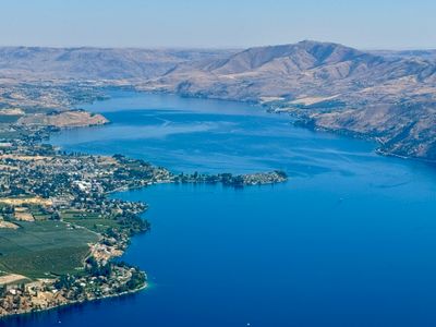
Chelan,
Washington
Overview
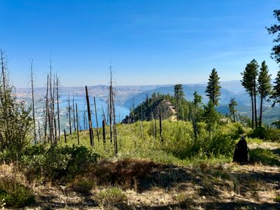
If you happen to look across the lake from around the Manson area on the north shore of Lake Chelan, you may have noticed Slide Ridge - a prominent ridge running along the opposite shore of Lake Chelan. While there are no official trails in the area, what appears to be an old fire line provides an easy way to access a sub ridge from the forest service road that provides outstanding views of Lake Chelan. There is a pullout on the side of the road, and it's relatively easy to find a 20 foot wide clearing which descends down towards the ridge. While the fire cut is devoid of large vegetation, it is not a hiking trail and you will pick your way through fallen branches and may need to side-hill some of the steeper slopes (not an appropriate hike for people who are only comfortable on trail). In less than a mile of hiking, you will find yourself on the ridge, with ample opportunities for amazing views of Lake Chelan. While the lake side of the ridge is extremely steep, the other side is more moderate and one can do the hike without any serious exposure. Of course there are opportunities to get close to the edge, but use your discretion as falling down the ridge would be life changing, and not in a good way. A little under two miles into the hike provides a good turnaround point, as the ridge starts to descend more steeply at this point. Retrace your steps back to the car.
Directions
Parking
Trip Reports
Ever since moving to Manson, I have wanted to get out onto Slide Ridge - I stare at it every day from our house. A while back I had noticed on satellite images there appeared to be a swath cut through the forest from the road to one of the more striking parts of Slide Ridge, a secondary ridge coming off the main part of Slide Ridge which contains the avalanche path coming down to Lake Chelan. I assumed it might have been an old road now overgrown, but after hiking it, I am pretty sure it is a fire cut, possibly from the Twenty Five Mile Creek fire in 2021.
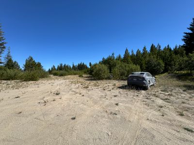
This was only my second time up Slide Ridge Road, the other occasion being a fun fall hike on Stormy Mountain to view the larches with my family a couple of years ago. I had plugged the coordinates into Google Maps, which I was thankful for, as even though I look at the ridge every day, I wouldn't have been certain I had the correct pull out without the confirmation of the map. After parking my car in the pullout, I followed an opening in the vegetation and after a hundred yards or so was confident this was the cut I saw on the satellite images.
It appears to be a relatively new fire cut, as it is well defined without a lot of vegetation growing. There were quite a bit of branches on the ground, but all things considered, it was pretty easy to navigate through the cut. It will start to become more overgrown in the future, but I'm sure that will take some time.
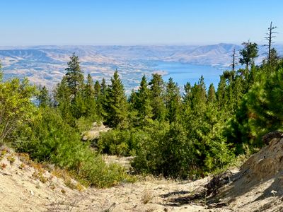
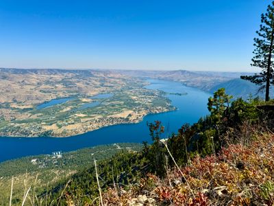
In less than a mile I was on the sub ridge, and found a spot that allowed me to safely get up to the edge and look down over 3,500 feet below to Lake Chelan. While the east side of the ridge that drops down to the lake is very steep, the west side is more mellow. There were a couple of areas I had to hike down that were on the steeper side, but there were small sections and had no exposure.
Living in the area and seeing the lake every day, I didn't expect to take so many photos. But it was a different perspective of the lake, and it is quite striking being so high above with unobstructed views. Not to mention a little adrenaline bump every time I got close to the edge for a photo.
I lost track of the fire cut at times, as the terrain was fairly open and it was easy to hike near the edge. It looked like the cut veered more to the western side of the ridge, and in sections where there was thicker vegetation it was easy to pick up the cut again. After a while, I saw a knob which I recognized, and figured that would be a good turn around point.
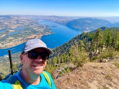
Reaching the knob, I found a nice rocky outcropping to sit on and hydrate and eat while I took in views of the lake. I couldn't stop thinking about how if this was turned into a legitimate trail, it would make hands down the best car accessible hike in Lake Chelan.
After a nice long break, I began the trek back up. On the way down, I hadn't really noticed the heat, but that definitely wasn't the case on the way back up. It was in the mid 90's, and man was I feeling it on the steeper sections. About half way back up my wife texted saying she had picked up my son and they wanted to know if I could snap a photo of them on our deck. I zoomed in as much as I could with my iPhone, but couldn't make them out.
Fun to get off trail and explore something I look at every day. I think it's doable for my family, although I would definitely opt for cooler temperatures next time.